
Sea Kayaking in Kerry: The Ring of Kerry from the Water
Sea Kayaking in Kerry: The Ring of Kerry from the Water
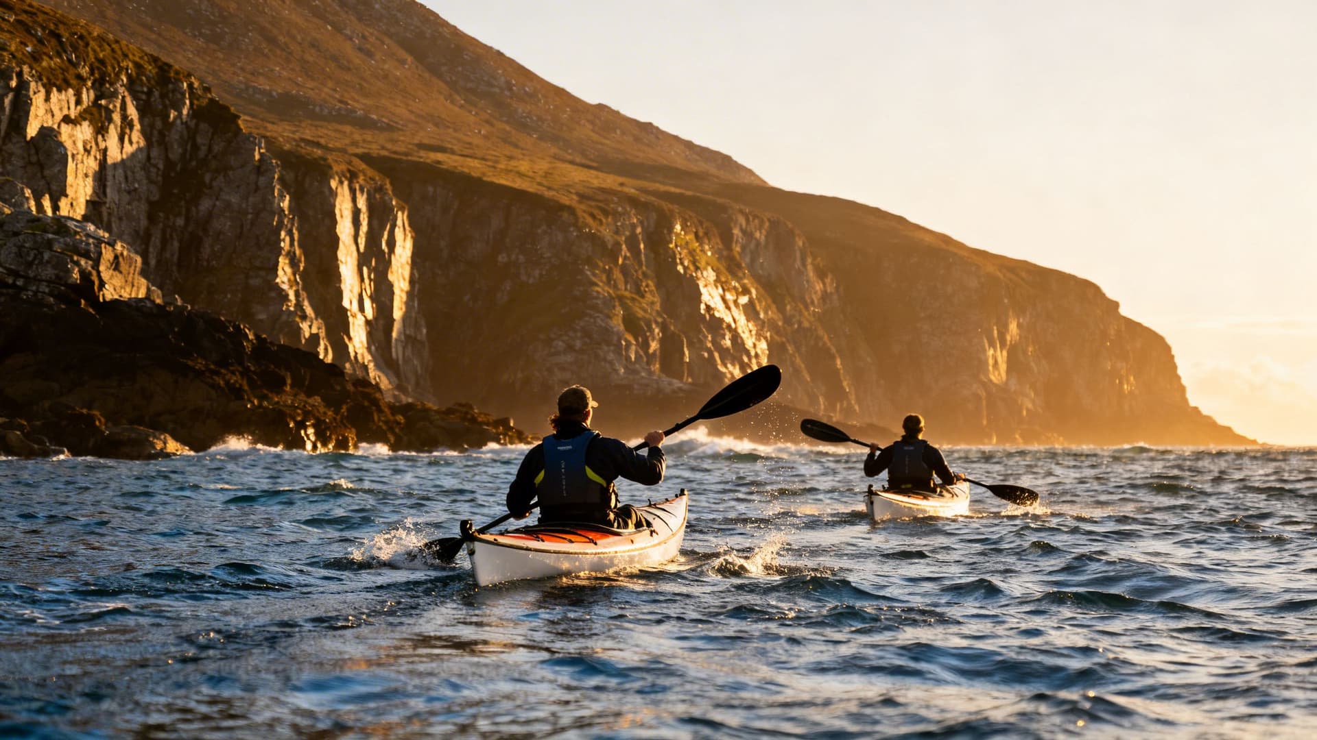
The coaches start early. By nine in the morning the road along the Iveragh Peninsula is filling with tour buses doing the Ring in both directions, passengers watching Kerry from above as the driver narrates the highlights. From the water, in a kayak, at the same hour, the road is invisible. The cliffs above you have no car parks on them. The inlet you've paddled into doesn't appear on the road map. The Skellig rock — Skellig Michael — is visible twenty kilometres to the southwest, darker than the water, catching the morning light on the side that faces you. Nobody is talking.
Kerry has the kind of name recognition that carries across generations. The diaspora feels it — not just the landscape but the weight of what the county has meant to the Irish families who left it. Sea Kayaking in Ireland: A Complete Guide maps the full scope of paddling around the Irish coast. This article is specifically about Kerry: what the Iveragh Peninsula looks like from the water, what the Skellig approach involves, and what makes sea kayaking in Kerry different from anywhere else on the Atlantic coast.
What the Ring of Kerry Looks Like from Sea Level
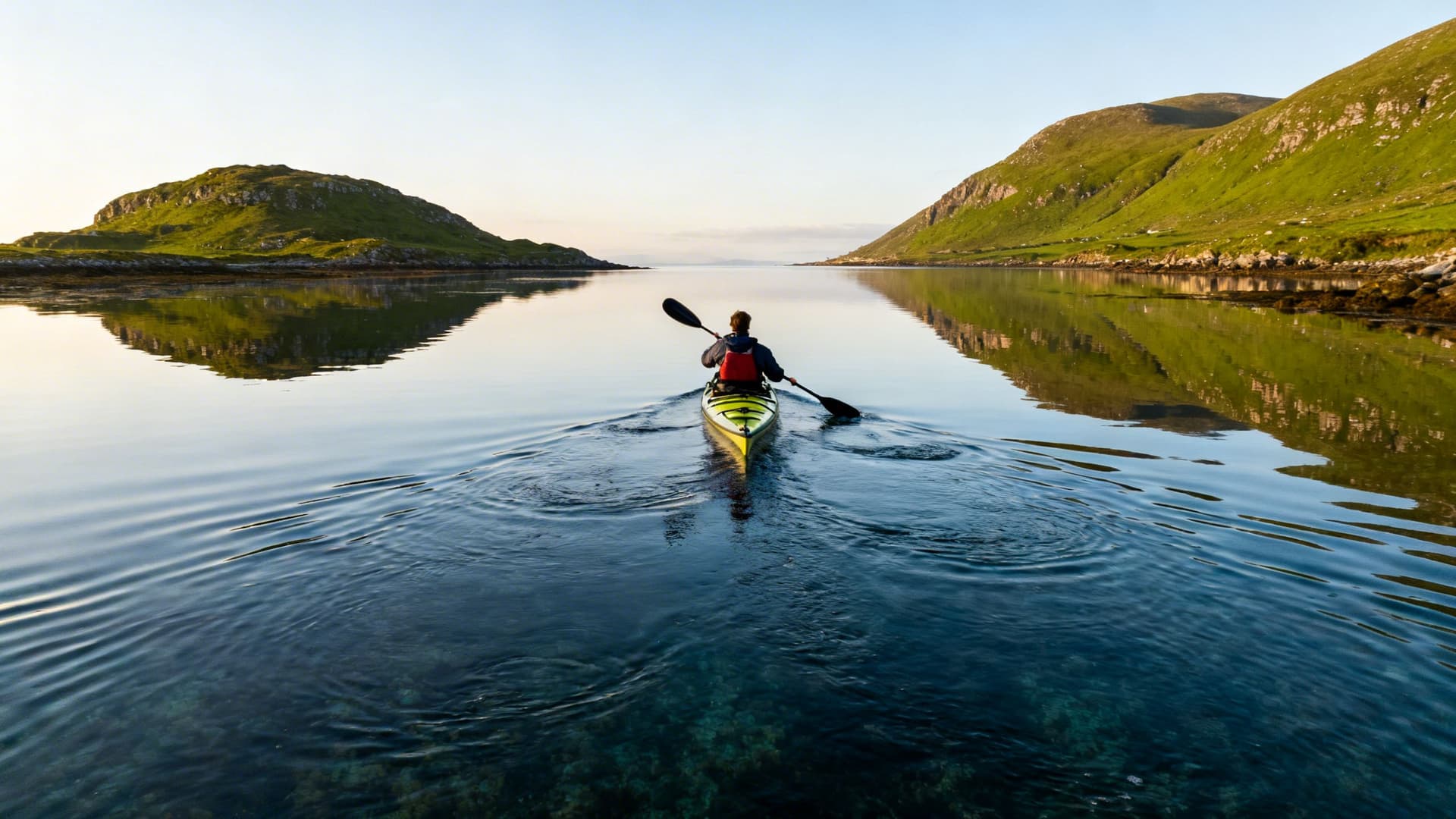
The Ring of Kerry as a driving route is a series of viewpoints — pullouts where you stop, take a photograph of the water below, and get back in the car. From a kayak, you remove the layer of observation entirely. You are in the photograph.
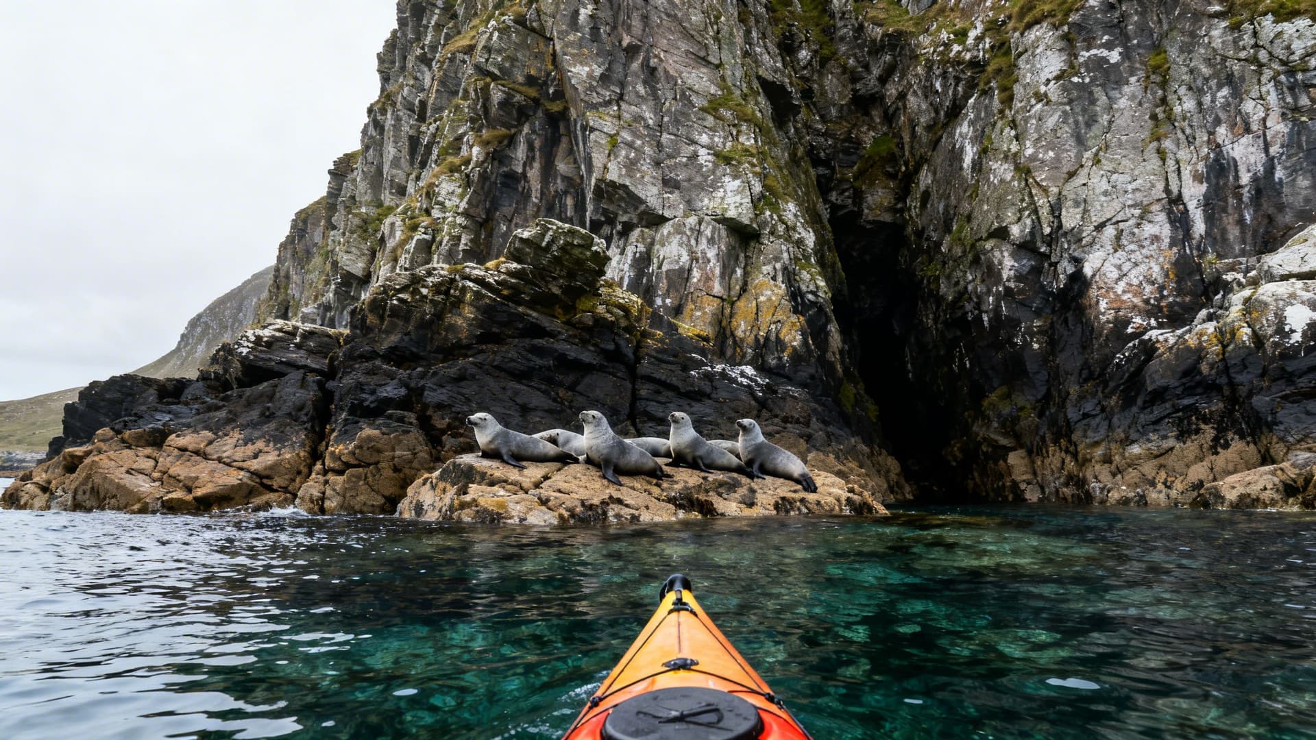
The Iveragh Peninsula is the largest of the Kerry peninsulas, and it extends into the Atlantic with a coastline that is, in places, almost inaccessible from above. The cliffs between Waterville and Ballinskelligs drop directly to the water with no beach access. The coves along the south shore are reachable only by boat. What you see paddling these sections are cliff faces that most visitors never approach closer than a kilometre — seal colonies on rocks that appear on no tourist map, water the colour of the Atlantic at its cleanest, which in Kerry, with no major rivers running into the southern coast, is very clean indeed.
The contrast with the road above is not symbolic. It is literal and consistent. You paddle past the stretch of coast where coaches slow down for photographs, and from where you are sitting in the water, the road is invisible. The silence is not occasional — it is structural. The only sounds are tidal.
The Iveragh Peninsula: Key Paddling Sections
Three sections of the Iveragh coast are regularly paddled by guides who know Kerry's water, and each has a different character.

Ballinskelligs Bay is the most sheltered and the most accessible entry point for paddlers arriving in Kerry. The bay opens southward toward the Skelligs and has a quality of afternoon light that photographers come specifically to capture — the Skellig rock silhouetted against a western sky. The bay's southern reaches bring you close to the ruins of Ballinskelligs Abbey on a low promontory, reachable by sea on calm days in a way that is unreachable on foot without crossing private land.
Derrynane Bay and the Kenmare Estuary approach offers more protected water and introduces you to the complex tidal geography of the inner Kerry coast. The bay itself is relatively sheltered; the stretch westward toward Lamb's Head and beyond becomes progressively more exposed. The old smuggling coves along this stretch have a specific texture — narrow inlets that open into sheltered pools behind rock formations. Local knowledge of which ones are accessible at which states of tide is the difference between a planned stop and a scrambled landing.
St Finian's Bay on the western end of the peninsula is the closest launch point to the Skelligs and the starting point for any serious attempt at the outer island approaches. On days when the Atlantic swell wraps around Bolus Head, it is also one of the rougher stretches of water on the south Kerry coast. The bay itself is protected; the water immediately outside it is not.
The Skellig Approach: What Paddling Toward Skellig Michael Actually Involves
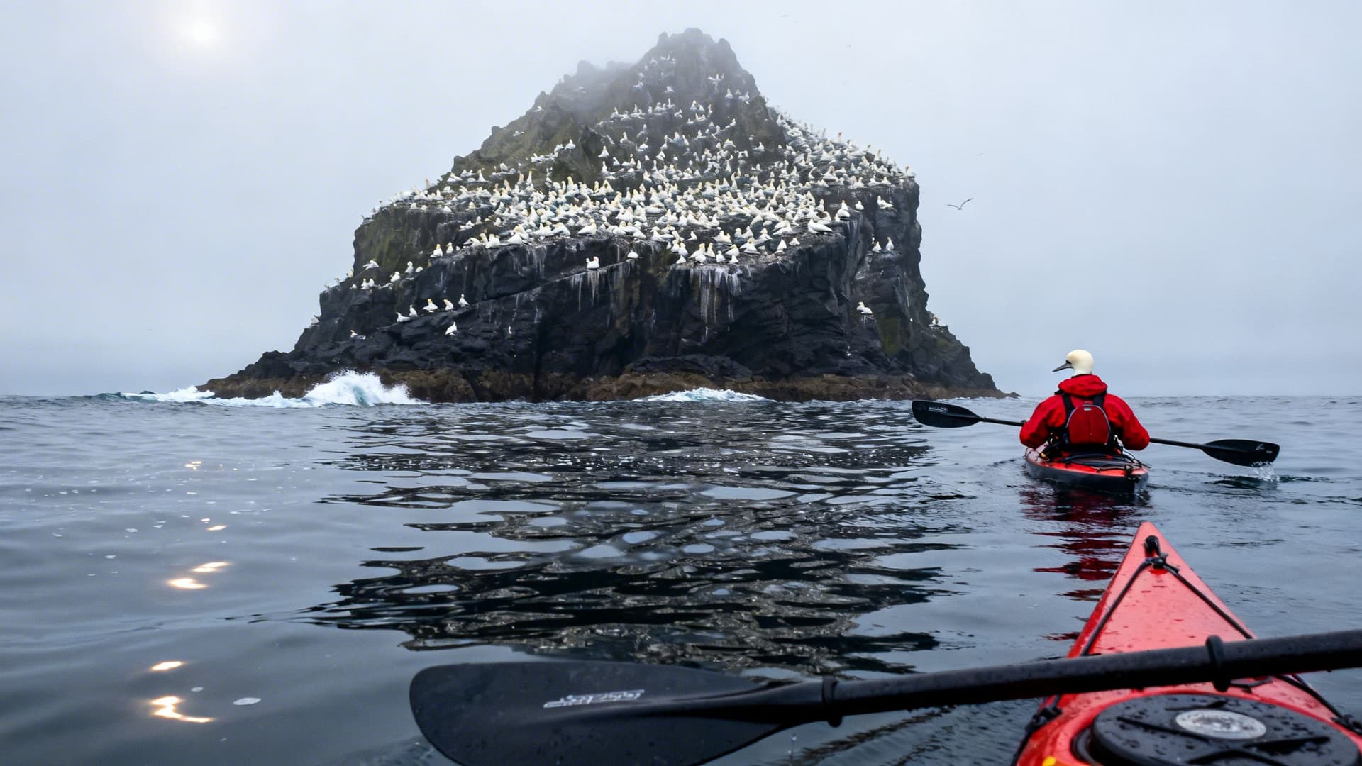
Skellig Michael is a UNESCO World Heritage Site — a rock rising 218 metres from the Atlantic, with a sixth-century monastery built on ledges near the summit. Approximately 130,000 people visit by ferry in the summer season. A fraction of that number have ever approached it from a kayak.
The crossing from St Finian's Bay to Skellig Michael is approximately twelve kilometres of open Atlantic water. The sea between the mainland and the Skellig rocks offers no shelter. Whatever the Atlantic is doing on a given day is what you paddle through, with no landmass providing wind shadow and no gradual build — conditions at the Skelligs can run significantly different from the shore forecast. The passage requires genuine sea kayaking competence: the ability to read a deteriorating swell, manage a loaded sea kayak in confused water, and make a rational decision to turn back if conditions change.
Most paddlers who approach the Skelligs stop at Little Skellig — closer, visible in detail from the water, and home to the second largest gannet colony in the world, somewhere above 35,000 breeding pairs. The noise is remarkable. The smell is worse. The sight of the colony from a kayak is one of the few experiences on the Kerry coast that is genuinely difficult to describe.
Valentia Island and the Portmagee Channel
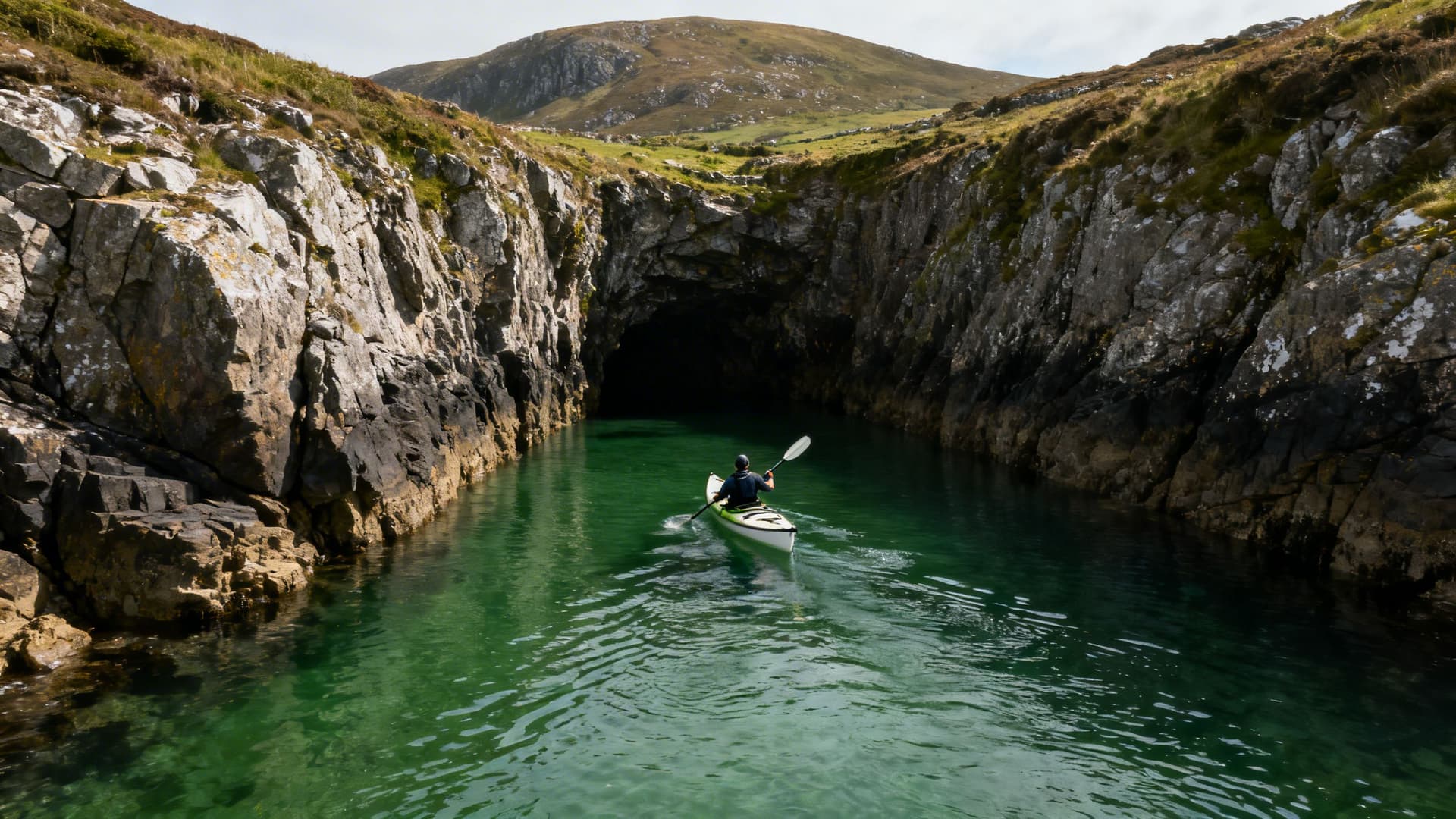
Valentia Island sits at the estuary mouth north of Portmagee, connected to the mainland by a bridge at one end and a small ferry at the other. The Portmagee Channel — the narrow strip of water between Valentia and the mainland — is sheltered, tidal, and a different class of paddling from the open coast.
The channel is navigable at most states of tide and offers several kilometres of protected water with the mainland shore on one side and the island on the other. Knightstown on the eastern tip of Valentia is reachable by kayak from Portmagee, through water that is, in the right light on the right morning, close to surreal in its stillness. The island above is the kind of quiet that Kerry was before the summer coaches.

The tidal flow through the channel needs reading. It runs north on the flood and south on the ebb, and the difference between paddling with it and against it over a stretch of enclosed water is measurable in effort. A guide who knows the channel can time a route so that you move with the tide in both directions — out on one flow, back on the other — which is the kind of planning that changes what a morning on the water actually feels like.
Sea Life on the Kerry Coast
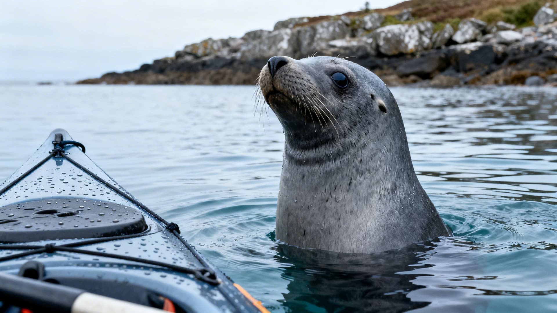
The Iveragh Peninsula coastline has concentrations of grey seals that are unusually approachable from a kayak. Grey seals are curious animals on the water, and a slow-moving kayak registers to them differently from a motorboat — they come close, observe, occasionally follow. The rocks at the eastern end of Ballinskelligs Bay have a regular haul-out in most months.
Bottlenose dolphins are present in Kerry waters year-round. Minke whales move through the outer waters in summer and autumn. Basking sharks appear in the outer Kenmare estuary and the approaches to St Finian's Bay from May onward — moving slowly at the surface, filtering plankton, entirely indifferent to a kayak floating ten metres away. The first time you see a two-metre dorsal fin clearing the surface beside your boat is approximately one second of panic followed by ten minutes of watching something remarkable.
Choughs — the red-billed crow that appears on Kerry's county crest — nest in the cliffs above the paddling routes on the south Iveragh coast. You will hear them before you see them.
Why You Need a Local Guide for Sea Kayaking in Kerry
Kerry's coast is not technically complex from end to end, but the sections that matter most are. The tidal geometry around Valentia, the swell forecasting for anything approaching the outer Skelligs, the launching access points that shift with the tide on the south Iveragh shore — all of these require specific, seasonal knowledge that doesn't exist in the same form in a guidebook or an app.
The guides who paddle Kerry regularly carry something more specific than general sea kayaking competence. They know which coves on the Derrynane section are accessible at low water and inaccessible at high. They know which direction the swell is wrapping around Bolus Head before the hour-by-hour forecast updates. They know the landowners whose gateways provide the only vehicle access to launch points on stretches of coast with no public slipway.
Kerry sea kayaking guides are also, typically, people who live in Kerry and have done for most of their lives. The knowledge is embedded. Sea Kayaking Along the Dingle Peninsula: Paddling the End of the World covers the other Kerry peninsula in detail — the tidal complexity and quality of the Atlantic water are the same across both; the specific passages and landing spots are entirely different.
Meet a Local Guide
Hello.
Frequently Asked Questions
Is sea kayaking near the Skelligs safe?
The open crossing to Skellig Michael is a serious sea kayak route requiring significant experience — this is not a stretch of coast for beginners or independent paddlers without a strong track record in exposed Atlantic water. Paddling within Ballinskelligs Bay and along the inner Iveragh shore is accessible to paddlers with a guided session or two behind them. The outer Skellig crossing is a separate category entirely.
What is the best time of year for sea kayaking in Kerry?
May, June, and September offer the best balance of settled weather, manageable swell, and daylight. The summer ferry traffic to the Skelligs has either not yet started or has finished, and the outer water is less congested. When to Sea Kayak in Ireland: A Month-by-Month Guide to Conditions, Light, and the Atlantic Swell covers this in full, but Kerry-specifically: the light in late April and September on the Iveragh coast has a quality that paddlers return for year after year.
Can you kayak to the Blasket Islands from Kerry?
The Blasket Islands are accessed from the Dingle Peninsula rather than the Iveragh Peninsula — the approach is from Dunquin on the north Dingle coast. Sea Kayaking Along the Dingle Peninsula: Paddling the End of the World covers the Blasket approach in detail, including tidal windows and what you find when you land.
Do you need experience to sea kayak in Kerry?
For the inner sections — Ballinskelligs Bay, the Portmagee Channel, sheltered stretches of Derrynane — guided sessions are achievable for paddlers who have never kayaked before. For anything approaching the outer Skelligs or the exposed western Iveragh coast, previous sea kayaking experience in tidal water is a genuine prerequisite, not a soft recommendation.
What Kerry Looks Like When You've Paddled It
Most people drive the Ring of Kerry once. Some come back. The ones who've done it from the water return because they've seen a version of the peninsula that doesn't exist from a car window — the Skellig rock in the early light, the seal colonies below the cliffs, the silence on the channel while the road above fills. Kerry from the water is not a better version of Kerry from the road. It is a different place entirely.
Sea Kayaking in Ireland: A Complete Guide covers the full landscape of paddling around the Irish coast — day trips, multi-day circuits, equipment, and how to choose a guide who matches where you are in your paddling life. Sea Kayaking to Ireland's Islands: Inishmurray, the Arans, Inis Bofin, and the Crossings in Between covers the island-approach dimension in detail, including the crossings that require the same tide and swell reading the Kerry outer coast demands.
Table of Contents
Share this post
More from the Blog

Bog Bodies of Ireland: Where Ancient Remains Meet the Bog
Ireland's bog bodies are among the best-preserved prehistoric remains in Europe. Here's where they were found, what they reveal, and how to see them with a local guide.

Bog Oak Ireland: The Ancient Wood Preserved in Peat
Bog oak is ancient oak wood preserved in Irish peat bogs for thousands of years. Learn how it forms, where to see it, and why Irish craftspeople still value it today.

Ireland's Bogs & Peatlands: A Complete Guide to the Landscape, History and Wildlife
Ireland's bogs and peatlands shaped its culture, climate, and wildlife. Discover raised bogs, blanket bogs, fens, turf-cutting heritage, bog bodies, and where to explore with a local guide.