
Sea Kayaking to Ireland's Islands: Inishmurray, the Arans, Inis Bofin, and the Crossings in Between
Sea Kayaking to Ireland's Islands: Inishmurray, the Arans, Inis Bofin, and the Crossings in Between
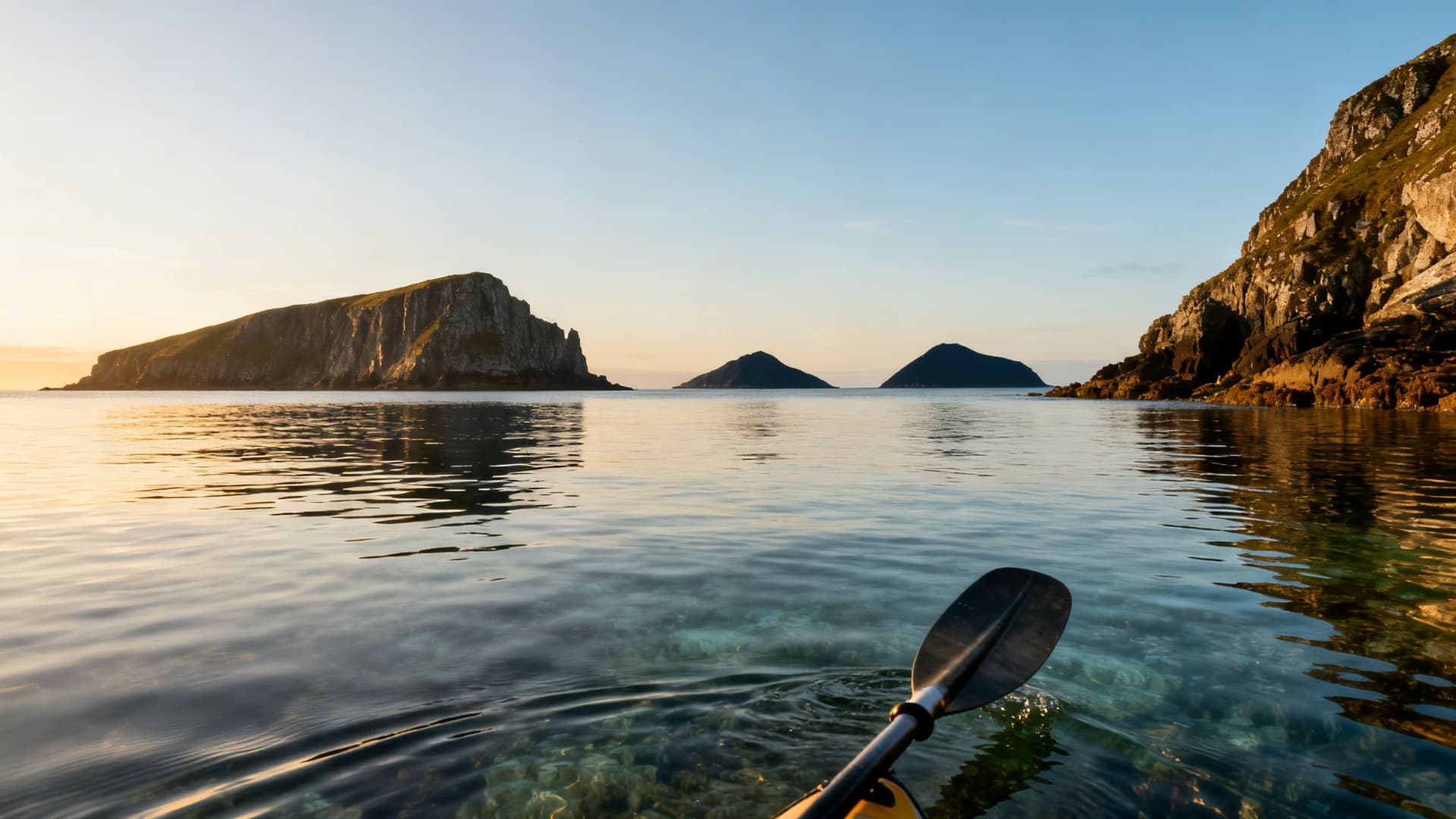
You are three miles offshore and the mainland has become a line of hills behind you. The island you are paddling toward has been growing for the last forty minutes — a shape on the horizon that first looked like cloud, then like rock, then, gradually, like walls. There are walls. Stone walls built without mortar, enclosing a monastery that was occupied continuously for four centuries before the Viking raids ended that. You are the only boat on the water. The ferry doesn't come here. There is no ferry.
Ireland has over three hundred islands. More than a hundred are within paddling range of the west and northwest coast. Sea Kayaking in Ireland: A Complete Guide covers the full scope of what Atlantic paddling here involves. This article covers the island crossings specifically — Inishmurray off the Sligo coast, the Aran archipelago in Galway Bay, and Inis Bofin in north Connemara — what each crossing actually requires, and what you find when you land.
The Islands That Are Reachable from the Water
Most of Ireland's inhabited and formerly inhabited islands are reachable by kayak from the mainland, given the right conditions. The question is never purely distance — it is the combination of distance, tidal current, prevailing swell, and what the crossing looks like when conditions change two kilometres from shore.
The west coast island crossings divide roughly into three categories. The first is sheltered crossings — distances under three kilometres with natural wind shadow from a headland or adjacent island, where conditions are consistently readable. These are appropriate for paddlers with guided experience behind them. The second is moderate crossings — four to six kilometres over open water with limited shelter, where tide and swell need reading and where a guide's decision to proceed or delay is based on more than the hour forecast. The third category is serious open crossings — Inishmurray, the outer Aran run from the Galway coast, the approach to Inis Bofin in a northwesterly. These require genuine offshore sea kayaking competence and a guide who knows what the Atlantic does on that specific stretch of water in that specific season.
What you find on the other side of a serious crossing is usually the point. The islands that are hardest to reach are the ones least visited, and the ones least visited are where you find the early Christian monasteries with their roofs still on, the seabird colonies that have never been managed, the beaches where you are the first person of the year to walk.
Inishmurray: The Monastic Island off the Sligo Coast
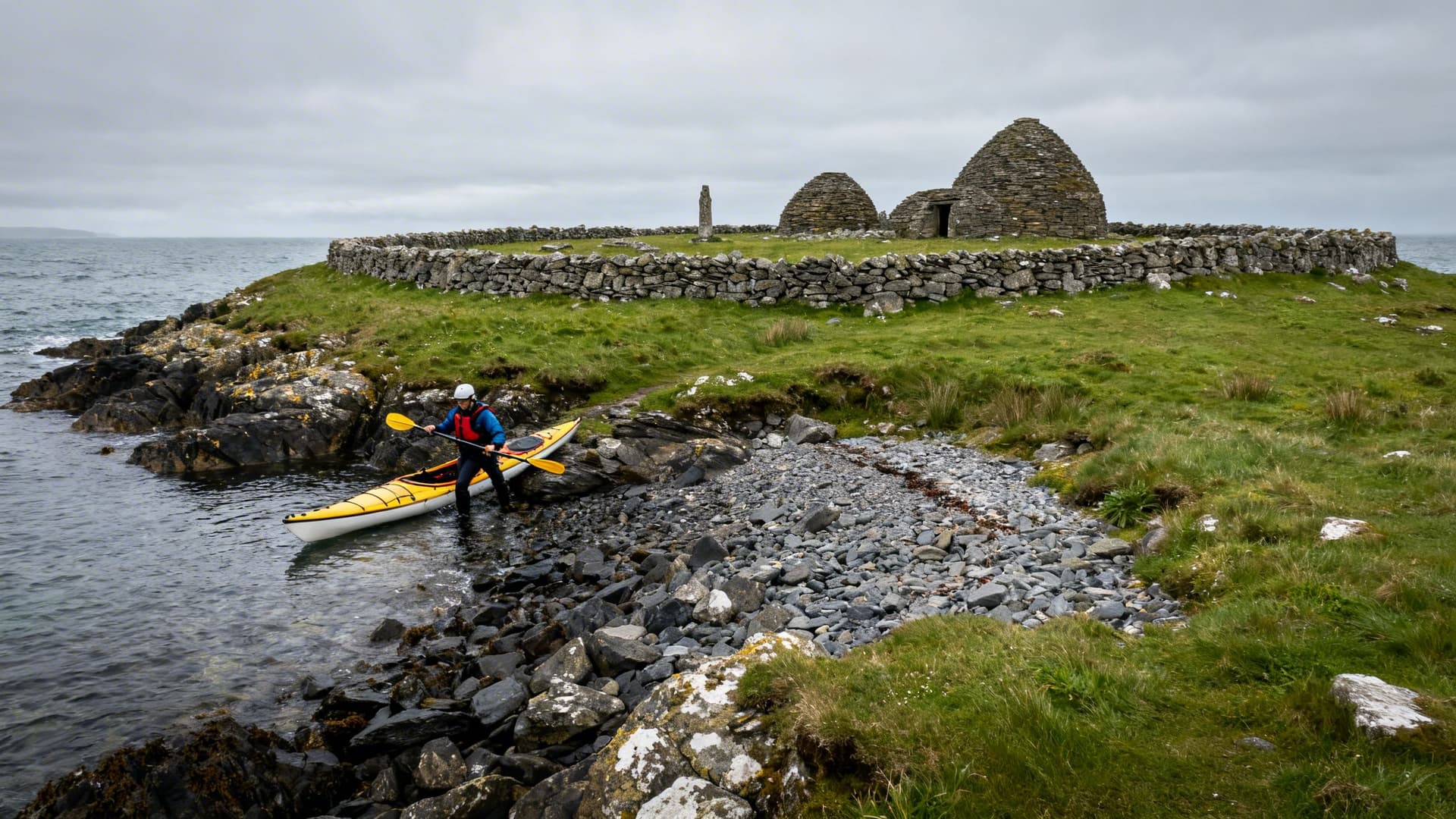
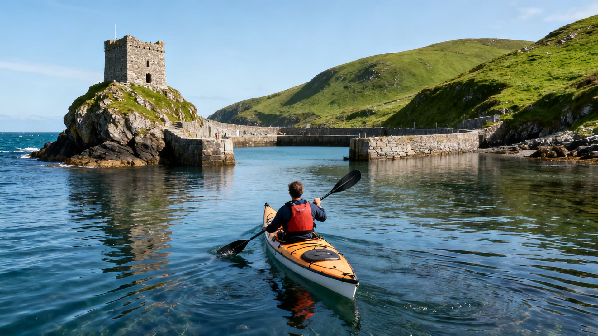
Inishmurray sits seven kilometres off the Sligo coast, in an exposed stretch of Atlantic water with no natural shelter once you leave the lee of the Mullaghmore headland. The island was inhabited continuously from the sixth century until 1948, when the last residents were evacuated at their own request. What they left behind is one of the best-preserved early Christian monastery complexes in Ireland — a cashel enclosure with its stone walls still standing to head height, beehive cells, multiple oratories, and a collection of cursing stones that were turned to call down misfortune on enemies and are, by local tradition, not to be repositioned by visitors.
Meet a Local Guide
Hi Folks,
The crossing from Mullaghmore is approximately seven kilometres of open water. The tidal stream runs broadly northeast-southwest through the passage, and the swell wrapping around the southern end of the island can run differently from the swell in the open crossing depending on how the Atlantic is behaving at the western face. On a calm day in early summer, the crossing is one of the finest paddles on the northwest coast — clear water above a sand bottom you can see from the surface in the shallows, the monastery walls emerging as you round the headland onto the southern shore. On a day when the Atlantic is moving, the crossing is not a trip for paddlers who have not spent significant time on exposed water.
The island is uninhabited. You pull up on a shingle beach, drag the kayak above the tide line, and walk into a site that most of the people who have ever heard of Inishmurray have never seen. That asymmetry is real, and it doesn't diminish.
The Aran Islands: Paddling the Galway Bay Archipelago
The three Aran Islands — Inis Mór, Inis Meáin, and Inis Oírr — sit across the mouth of Galway Bay in a line running northwest to southeast. They are among the most visited of Ireland's offshore islands, but the ferry routes and air service that connect them to the mainland have created a version of the islands that is, necessarily, the version accessible to most visitors. From a kayak, the version is different.
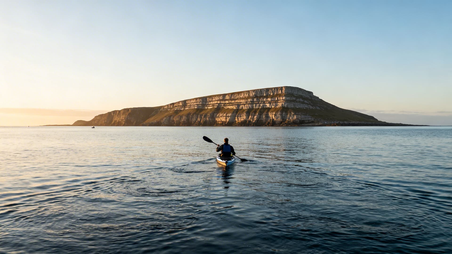
The approach to Inis Mór from the Connemara coast at Rossaveal is approximately fifteen kilometres of open Atlantic water — the full crossing, with no shelter in the middle and tidal streams that set you south or north depending on where you are in the cycle. This is the route the diaspora returns for: Aran families from Boston and Chicago who have heard about the islands for their entire lives, who want to approach by water the way the currach fishermen approached, and who find, on a still morning when Inis Mór grows from a line on the horizon to a wall of limestone terracing, something that a tourist-board photograph does not convey.
Inis Meáin and Inis Oírr are quieter. The island-to-island passages between them are shorter than the mainland crossing and navigable by paddlers with guided Atlantic experience. Inis Meáin in particular — the middle island, least visited, most intact in terms of its Irish-speaking community and stone field systems — is the one that paddlers who have done the Aran crossing tend to describe first.
Inis Bofin: The Island at the End of Connemara
Inis Bofin sits eight kilometres off the north Connemara coast, past the headland at Cleggan. It is inhabited — the population is around 160 — and accessible by regular ferry from Cleggan Pier. It is also the most accessible serious crossing on the Connemara circuit and the island that most first-time multi-day paddlers in the region include in their route.
The crossing from Cleggan is exposed on its western side to whatever the Atlantic is doing, with a swell that refracts around Inis Bofin's western headland as you approach. The island's sheltered harbour on its eastern side is a different proposition from the exposed approach — once inside the harbour mouth, you are in protected water with a natural anchorage that has been used by boats since the Bronze Age. A fourteenth-century Cromwellian fort stands on the rock at the harbour entrance.

Inis Bofin's interior is farmed, with a particular quality of light on the western pastures in the late afternoon that photographers come specifically for. There is a small hotel, a few pubs, a community that has been navigating the tension between island life and island tourism for two generations. Arriving by kayak rather than ferry changes the register of the visit — you have earned the crossing in a way that the ferry passenger has not, and the island knows it.
Reading the Crossing: Tide, Swell, and What You Can't See from the Shore
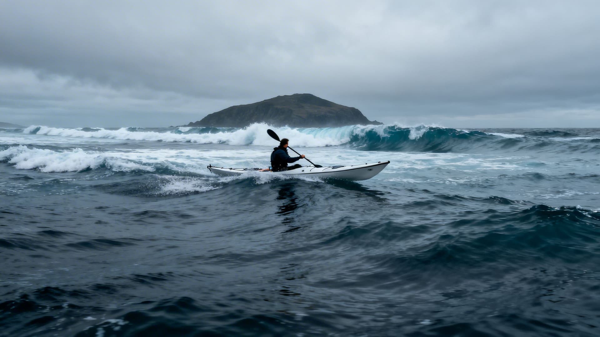
The standard mistake in planning an island crossing is treating the forecast as the decision. A three-metre Atlantic swell running at twelve seconds can look benign on a weather app and look entirely different when you are in a kayak at the halfway point of a seven-kilometre crossing and the period between crests shortens.
Island crossings on the west coast are governed by tide tables and by the live swell state in a way that coastal paddling is not. The tidal stream between the mainland and an offshore island is not uniform — it accelerates through passages, creates overfalls at headlands, and runs differently at the island's windward and leeward faces. A guide who has crossed to Inishmurray thirty times has a mental map of exactly where the tide sets you south and how to angle the crossing to arrive at the correct beach rather than the exposed western shore.
The swell window is the other variable. Atlantic swell generated by low pressure systems off Newfoundland arrives on the Irish west coast with a momentum that bears no relation to the wind conditions locally. You can paddle out in a flat calm and be in a two-metre swell an hour later as the groundswell fills in from the southwest. When to Sea Kayak in Ireland: A Month-by-Month Guide to Conditions, Light, and the Atlantic Swell covers the seasonal patterns in full — for island crossings specifically, May and early June offer the narrowest window of consistent swell combined with good visibility and long daylight.
Why You Need a Local Guide for Island Crossings
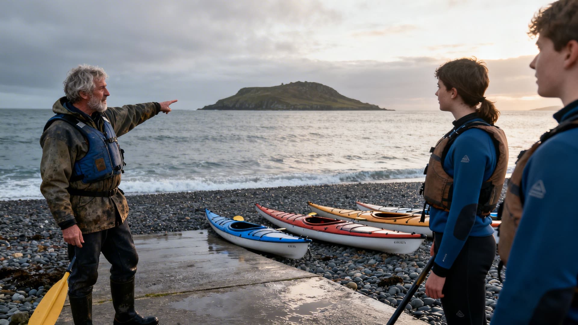
The islands that reward a kayak approach are the islands that are difficult to reach — which means the crossings require a level of oceanic knowledge that cannot be built from charts and weather apps alone. What a guide who runs these crossings regularly brings is not just safety. It is the knowledge of which crossings are achievable on which tides, which beaches provide safe landings in which wind directions, and what the island actually contains that isn't in any publicly available source.
Kerry sea kayaking guides who work the south coast have equivalent knowledge of the Skellig approach and the island approaches off the Iveragh Peninsula. On the Connemara and northwest circuit, guides who specialise in island crossings carry seasonal, accumulated understanding of specific passages that changes the nature of what you can do on those crossings. They know the Inishmurray landing in a southeast swell and the one in a northwesterly, and they know which is which before you have left the harbour.
Sea kayaking guides for Irish island crossings approach these trips differently from day sessions. The planning conversation covers your paddling background, target islands, realistic assessment of what the Atlantic is likely to do in your week, and contingency routes when the main crossing isn't achievable. That planning is the product.

Frequently Asked Questions
Can you kayak to the Aran Islands without a guide?
The full Aran crossing from the Connemara coast is a serious open-water paddle — fifteen kilometres of Atlantic with tidal streams and no shelter mid-crossing. Paddlers with significant offshore sea kayaking experience and appropriate equipment can and do make this crossing independently. For most paddlers approaching it for the first time, a guide who knows the Galway Bay tidal geometry and the conditions on both ends of the crossing is the difference between an achievable trip and a day spent watching the water from Rossaveal Pier.
What is the closest island crossing to a beginner route?
The island-to-island passages within the Aran archipelago are shorter and more sheltered than the mainland approach, and the crossing from Doolin in County Clare to Inis Oírr is approximately three kilometres — achievable for paddlers with guided coastal experience. For complete beginners, these crossings are still guided — the Atlantic does not offer the same margin for error as a sheltered bay session.
What is the best island for a first overnight kayak trip?
Inis Bofin is the most accessible serious crossing on the Connemara circuit and the most practical first overnight island. The harbour provides a sheltered landing in most conditions, the island has accommodation if you prefer a roof over a tent, and the crossing is long enough to feel earned without being the committed offshore passage that Inishmurray or the full Aran crossing requires. Multi-Day Sea Kayaking in Ireland: How to Plan a Paddle Camping Trip on the West Coast covers the preparation and logistics for overnight island circuits in full.
When is Inishmurray crossable by kayak?
The practical window for Inishmurray from Mullaghmore is May through September, with June and September offering the best combination of swell, visibility, and daylight. The crossing is weather-dependent — guides who run it regularly will tell you that two or three days in a typical week have conditions they'd consider acceptable for the crossing, and three or four do not. The planning conversation for Inishmurray starts with a five-day window, not a single target day.
What the Islands Hold
There is a specific quality to standing inside the Inishmurray cashel, or on the high western terracing of Inis Meáin, or on the beach at the back of Inis Bofin's inner bay where the currach fishermen pulled up, when you have arrived by kayak. The crossing was yours. The island is, for the hours you are on it, entirely quiet. The mainland — the coaches, the car parks, the commentary — is three miles of open water away.
Sea Kayaking in Ireland: A Complete Guide maps the full range of what is reachable from Ireland's Atlantic coast and how to match a route to your experience level. For those earlier in the paddling journey, Sea Kayaking for Beginners in Ireland: What Your First Session Will Actually Feel Like covers how the skill builds from the first session on a sheltered bay to the competence that makes island crossings achievable. The islands are there. The crossings are learnable.
Table of Contents
Share this post
More from the Blog

Bog Bodies of Ireland: Where Ancient Remains Meet the Bog
Ireland's bog bodies are among the best-preserved prehistoric remains in Europe. Here's where they were found, what they reveal, and how to see them with a local guide.

Bog Oak Ireland: The Ancient Wood Preserved in Peat
Bog oak is ancient oak wood preserved in Irish peat bogs for thousands of years. Learn how it forms, where to see it, and why Irish craftspeople still value it today.

Ireland's Bogs & Peatlands: A Complete Guide to the Landscape, History and Wildlife
Ireland's bogs and peatlands shaped its culture, climate, and wildlife. Discover raised bogs, blanket bogs, fens, turf-cutting heritage, bog bodies, and where to explore with a local guide.