
Kayaking the Cliffs of Moher: A View 700,000 Tourists Never Get
Kayaking the Cliffs of Moher: A View 700,000 Tourists Never Get
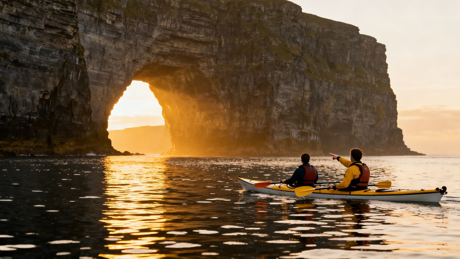
You are forty metres from the cliff face. The Atlantic is behind you, a slow swell lifting the kayak and setting it down again. Above you — all of it above you — is 214 metres of Clare limestone, vertical and dark with moisture, rising out of the water to a height that your brain struggles to process from this angle. Somewhere up there, visitors are looking down. You cannot see them. The observation platform, the visitor centre, the coaches in the car park — all of it might as well be on a different planet. From a kayak at the base of the Cliffs of Moher, the Ireland above the clifftop does not exist.
Over a million visitors walk the cliff path every year. They get a spectacular view — one of the best in the country. What they don't get is this: the sound of the Atlantic moving into the sea caves at the cliff base, the shadow of a stack of rock that extends into the ocean and blocks the sky, or puffins at eye level in April. Sea Kayaking in Ireland: A Complete Guide covers the full range of what Ireland's west coast offers from the water. This article is about one section of it — fourteen kilometres of Clare coast that you can only properly see from a kayak.
What the Cliffs Look Like from Sea Level
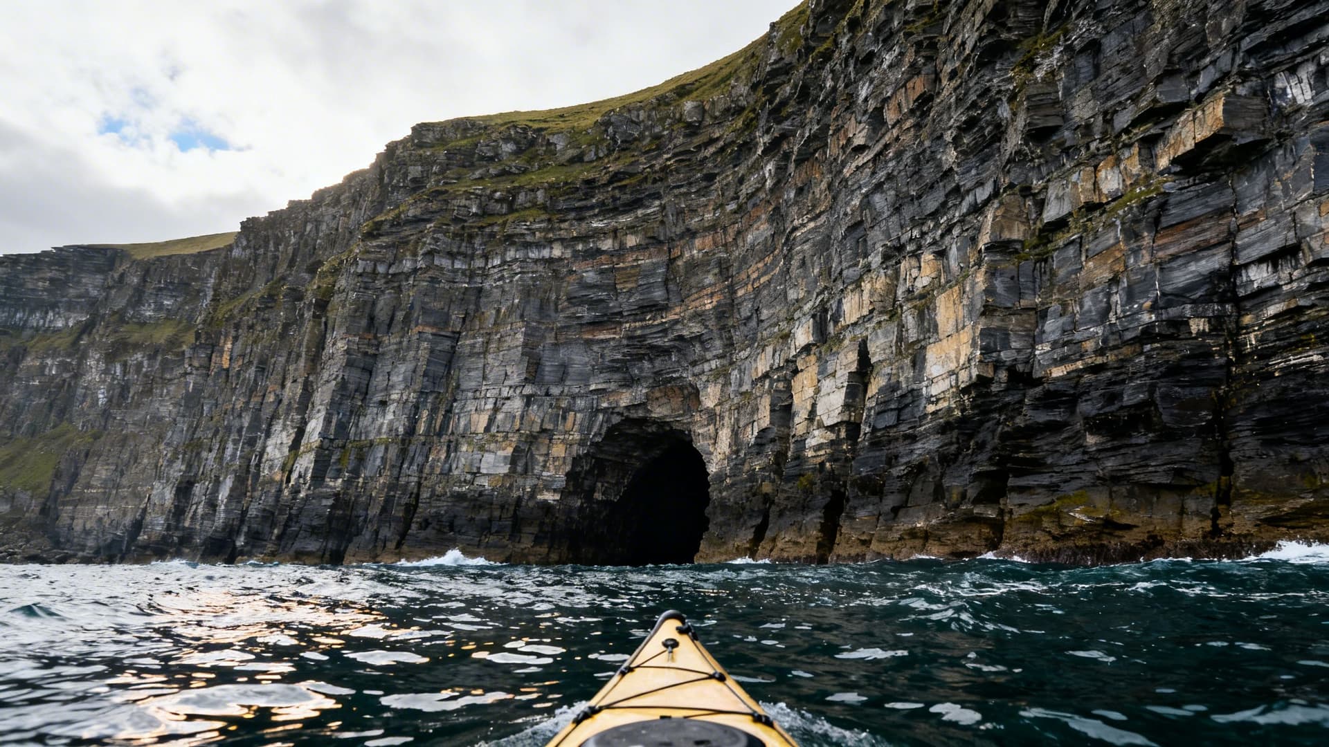
From the visitor path on top, the Cliffs of Moher read as height. You look down, and the sea is far below, and the scale is understood as distance. From a kayak at the base, the same cliffs read as weight. The cliff face starts at the waterline and rises without break or ledge until it disappears from your field of vision. You have to tip your head back to find the sky. The rock isn't just tall — it's present in a way that the cliff path doesn't prepare you for.
The base of the cliffs is a different geography entirely. Sea caves open into the rock at intervals — narrow arches leading into dark chambers where the swell moves in and out with a low, pressured sound. From the visitor platform above, these caves are invisible. From a kayak, you can paddle into them on calm days, your hull lifting gently on the swell, the cliff closing around you. The geology here is layered flagstone and shale — the same rock quarried across County Clare for centuries — and at water level you can read the strata like a book left open.
What the view from above shows you is the cliff. What the view from water level shows you is the cliff face, the cliff base, the sea caves beneath it, and the open Atlantic in front of it, all at once. The difference is total.
The Route: Doolin to the Cliffs

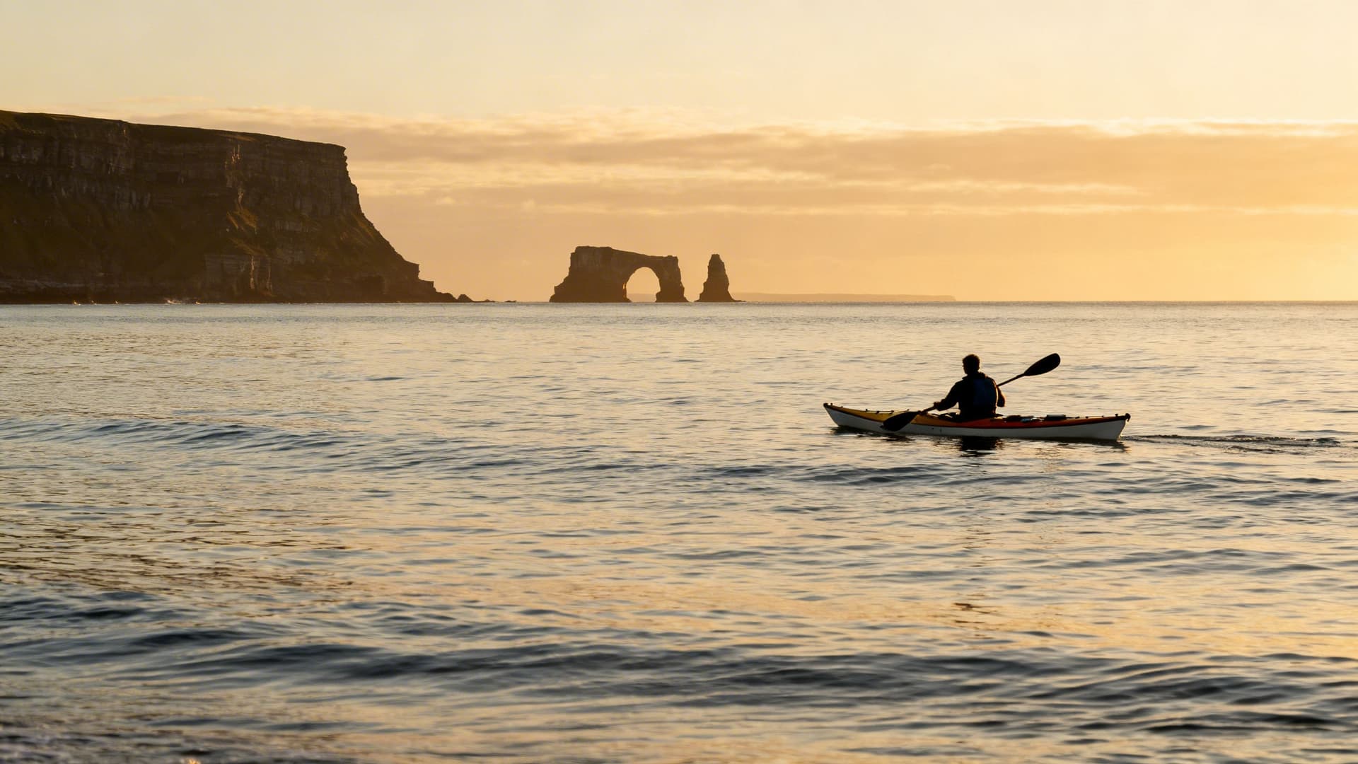
The standard approach is from Doolin, a small village on the Clare coast about four kilometres north of the cliffs. The paddle south along the coast passes sea arches and stacks well before the main cliff face begins — the coastline starts changing character roughly halfway along the route, and the sense of approach is gradual and earned. You arrive at the cliffs having already spent an hour on the water; your eye is calibrated to the scale of things.
The cliff face proper begins near Branaunmore, a sea stack that stands separately from the main cliff, weather-worn and vertical. From here the face extends south, and the paddle along its base takes thirty to forty minutes depending on pace and how long you stop. The cliffs reach their maximum height near Hag's Head at the southern end, and this is where the Atlantic exposure is greatest — the ocean has a long fetch here from the southwest, and on days with any swell running, the water at the base is restless.
The return to Doolin is the same coast in reverse, usually with the wind behind you. In summer, the light on the cliff face in late afternoon turns the flagstone a colour that isn't in any photograph you've seen — a low, warm light on black rock with the Atlantic going silver in front of it.
Puffins, Choughs, and What Lives in the Cliff Face
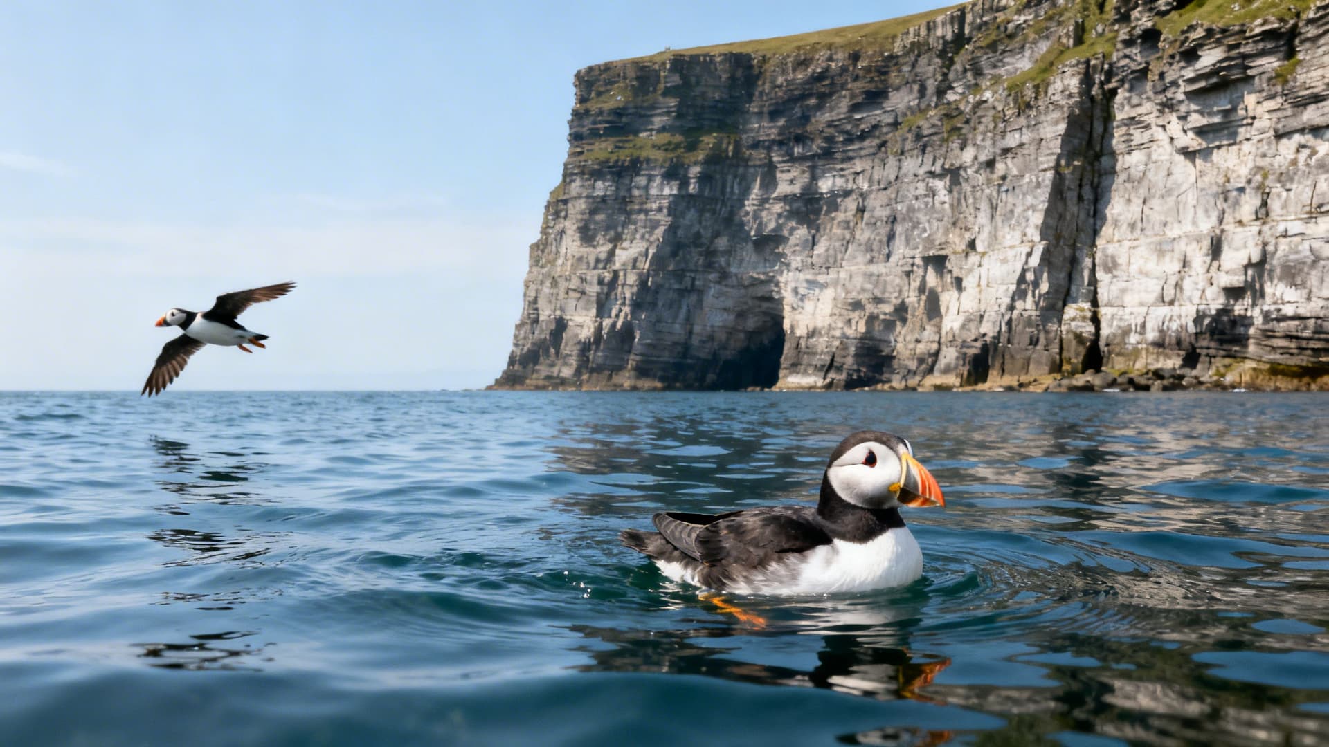
The Cliffs of Moher host one of the more significant seabird colonies on the Irish west coast, and from a kayak you are paddling through the middle of it. Puffins nest in burrows in the cliff face from April to July — at water level you see them bobbing on the surface ahead of you, or watch them fly low along the cliff base with their characteristic whirring wingbeat. At eye level in a kayak, a puffin is a small, exact bird with a complicated face. From the viewing platform above, they are invisible.
Choughs — red-billed members of the crow family, increasingly rare in Ireland — use the cliff face year round. Razorbills and guillemots nest in the ledges at mid-height, and the noise from a crowded ledge carries down to the water clearly. The base of the cliffs is good seal territory too: grey seals haul out on low rock platforms exposed at lower tides and watch kayaks pass with the incurious manner of animals that have decided humans are not worth the energy.
On the open water between the cliffs and the Aran Islands, dolphin and minke whale sightings are possible in summer. A guide who paddles this coast regularly will know where to look and when.
Reading the Atlantic Swell on the Clare Coast

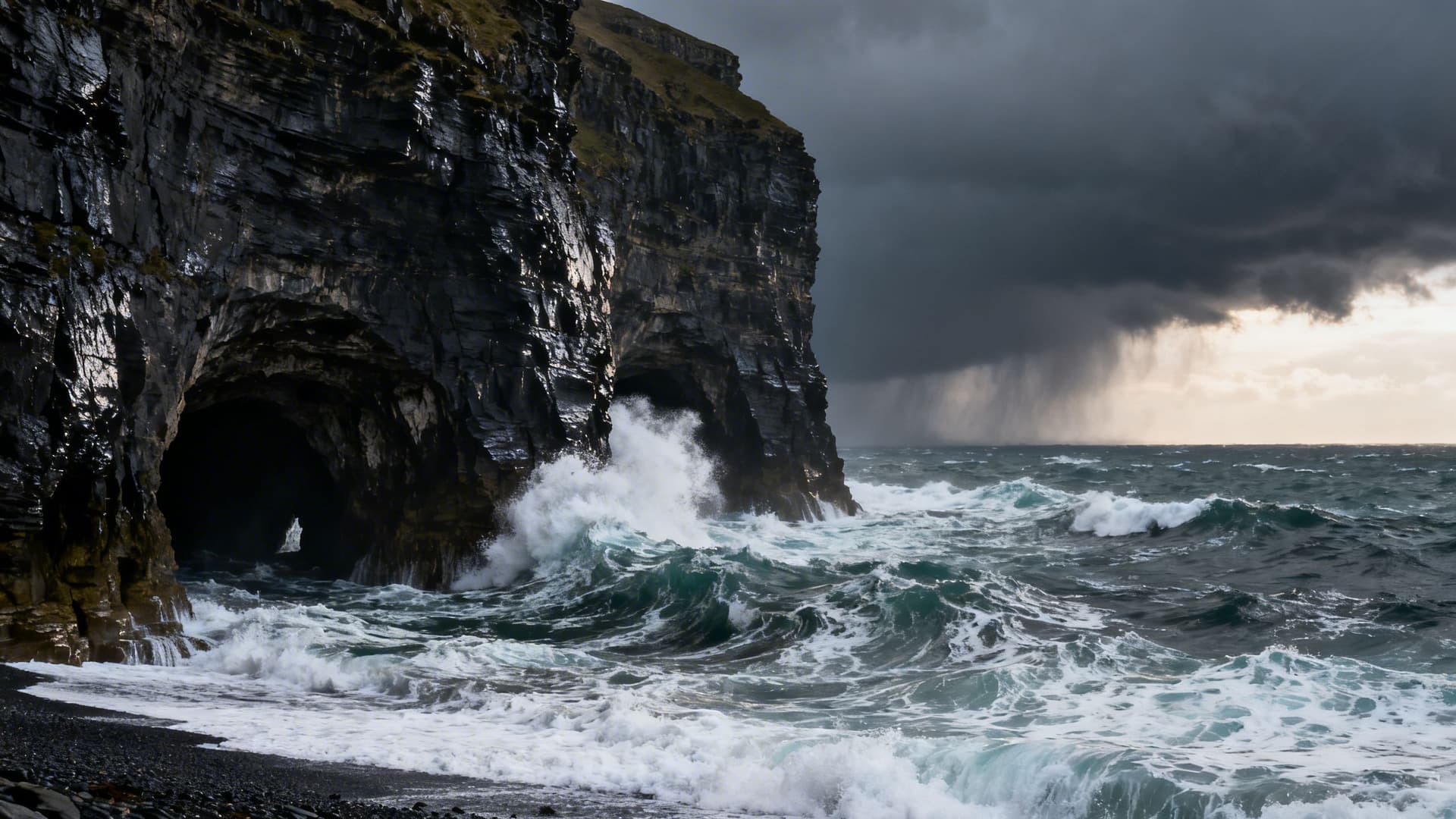
This is not a section to skip. The Cliffs of Moher face southwest into the full fetch of the Atlantic, and the swell on this coast is real, variable, and consequential. On a calm June morning, the water at the cliff base is glassy and the caves are accessible. On a day with a two-metre swell running, the same water is a different proposition entirely — swell deflects off the cliff face and conditions at the cave entrances can turn without much warning.
The Clare coast doesn't announce a change in conditions generously. Swell can build faster than a general forecast suggests, particularly when a frontal system is tracking north from the Bay of Biscay. A reading of "slight to moderate" from a national forecast can mean very different things at different points along this fourteen-kilometre face, depending on aspect, refraction off headlands, and the local geography of the seabed near the cliff base.
The paddle to the Cliffs of Moher is not a challenging route on a good day. On a bad day, it is not a route at all. The difference between those two days, and the ability to read one from the other in advance, is local knowledge that cannot be looked up.
Why You Need a Local Guide for Kayaking the Cliffs of Moher
There are regulations governing how close kayakers can approach the cliff face in certain conditions, and these vary by location and season. Launch points are specific — not every beach on this stretch of coast is suitable, and some apparent options are restricted or genuinely dangerous depending on conditions. The Clare coast swell pattern is hyperlocal: a guide who has been paddling this water for years carries a mental model of which days work and which don't that no app or forecast replicates.
The Cliffs of Moher are one of the most visited sites in Ireland. From the water, they are among the least visited — precisely because the route requires real knowledge of the Atlantic conditions on this particular coast. A Cliffs of Moher sea kayaking guide is not an added convenience here. It is what makes the trip possible rather than inadvisable.
For travellers who are newer to sea kayaking and want to understand what a guided coastal session actually involves before committing to a route like this one, Sea Kayaking for Beginners in Ireland: What Your First Session Will Actually Feel Like covers exactly that — including what level of experience a trip like the Cliffs of Moher actually requires.

Frequently Asked Questions
Can a beginner kayak to the Cliffs of Moher?
Not independently, and not without an honest assessment of conditions on that specific day. A guided trip with a qualified operator on a suitable day is accessible to paddlers with minimal experience — you don't need to be a strong kayaker to do the route in calm conditions. What you do need is a guide who can make the call about whether that day is viable, and who can manage conditions if they shift mid-route. The Atlantic is not a lake.
When is the best time of year to kayak the Cliffs of Moher?
May, June, and September offer the best combination of settled Atlantic conditions, long daylight, and — in May and September specifically — far fewer people on the cliff path above. The puffin colony is at the face from April through July, which is worth factoring in. July and August are reliable for light and temperature but Atlantic swell is less predictable than the calendar suggests.
How long does the kayaking trip take?
A guided trip from Doolin and back typically runs four to five hours including stops and time spent along the cliff face. Some operators offer options that extend to a crossing toward the Aran Islands from the southern end — a full-day commitment requiring more settled conditions and a higher base level of paddling experience.
Are the sea caves at the cliff base accessible?
On calm days, yes — some of them. The larger accessible caves can be paddled into on glassy water, and the experience of being inside the cliff with the Atlantic moving the hull gently beneath you is one of those things that doesn't translate in photographs. A guide will know which caves are open on any given day and which are not worth attempting.
The Cliffs of Moher will not be any less impressive from the cliff path. That view has earned its reputation over a long time. What a kayak gives you is a second view of the same cliffs — one that requires more effort, more planning, and a guide who knows the Clare coast well enough to tell you whether today is the day. For travellers using Sea Kayaking in Ireland: A Complete Guide to plan a broader trip along the west coast, the Cliffs of Moher are worth reserving for the right conditions. They are better for the patience.
Table of Contents
Share this post
More from the Blog

Bog Bodies of Ireland: Where Ancient Remains Meet the Bog
Ireland's bog bodies are among the best-preserved prehistoric remains in Europe. Here's where they were found, what they reveal, and how to see them with a local guide.

Bog Oak Ireland: The Ancient Wood Preserved in Peat
Bog oak is ancient oak wood preserved in Irish peat bogs for thousands of years. Learn how it forms, where to see it, and why Irish craftspeople still value it today.

Ireland's Bogs & Peatlands: A Complete Guide to the Landscape, History and Wildlife
Ireland's bogs and peatlands shaped its culture, climate, and wildlife. Discover raised bogs, blanket bogs, fens, turf-cutting heritage, bog bodies, and where to explore with a local guide.